Note: This is a developing story and will be updated.
Update Monday, March 16, 4:45pm:
A tornado watch remains in effect for parts of eastern North Carolina through 7 p.m. Affected counties, according to the National Weather Service, include Bertie, Camden, Chowan, Currituck, Gates, Hertford, Northampton, Pasquotank and Perquimans.
Five counties—Edgecombe, Halifax, Sampson, Wayne and Wilson—remain under a tornado watch until 8 p.m.
Models from the National Weather Service showed the highest likelihood of strong winds in the Triad and the Triangle in the late afternoon and early evening.
“As this storm moves across the state, North Carolinians should stay alert and be prepared to take cover if severe weather develops nearby,” Governor Josh Stein said in a press release this afternoon.
Monday, March 16, 9:45am:
The National Weather Service said this morning that the widespread strong to severe wind gusts will be the primary hazard. Wind gusts could reach 75 mph. There is also the potential for brief tornadoes. The likelihood of hail has reduced to “~5%, mainly because the likelihood a storm will remain isolated for long enough to produce large to very large hail is low.”
Sunday, March 15:
North Carolinians should take precautions against severe weather expected to hit Monday.
“Widespread thunderstorms are expected with damaging wind gusts likely. A few
tornadoes are possible,” according to the National Weather Service.
“The first round will be Monday morning and early afternoon when isolated severe thunderstorms are expected,” State Emergency Management Meteorologist Diana Thomas said in a video update on Sunday. “A second round is then forecast Monday late afternoon and evening.”
State emergency management officials cautioned that storm movement will be fast, so quick action is essential.
“Unusually severe weather is moving into North Carolina, bringing a risk of damaging wind gusts, thunderstorms, hail, and even tornadoes,” Governor Josh Stein said in a press release. “Please make sure emergency alerts are enabled on your phone and make a plan for how to keep yourself and your family safe.”
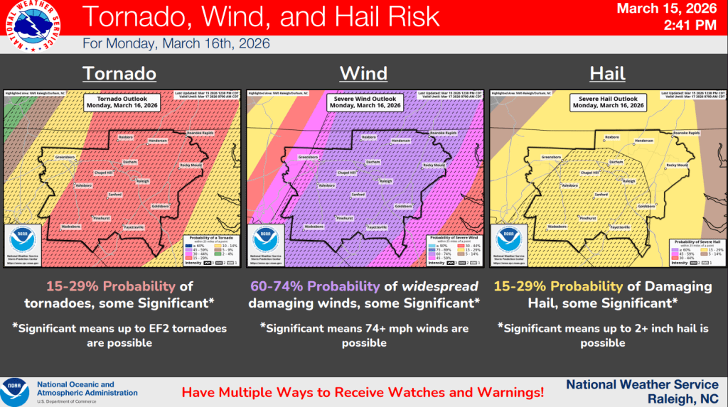
The biggest threats, according to the weather service, are to the eastern Piedmont across the Sandhills and Coastal Plain. The alert was issued for Person, Granville, Vance, Warren, Halifax, Forsyth, Guilford, Alamance, Orange, Durham, Franklin, Nash, Edgecombe, Davidson, Randolph, Chatham, Wake, Johnston, Wilson, Stanly, Montgomery, Moore, Lee, Harnett, Wayne, Anson, Richmond, Scotland, Hoke, Cumberland and Sampson counties.
School systems across the region are closed including Wake County, Guilford County, Winston-Salem/Forsyth County, Cumberland County, Johnston County and Durham County.
Meteorologist Thomas said damaging wind gusts could reach 74 miles per hour. The National Weather Service reported gusts of wind could reach 40 miles per hour even in areas not affected by the storms.
“While North Carolina is no stranger to severe weather, the introduction of a Level 4 out of 5 moderate threat is very rare in our state,” NC Emergency Management Director Will Ray said in a press release.
The National Weather Service moved from a system with three levels of risk to one with five levels of risk in 2015. Since then, the conditions have been deemed a level 4 of 5 only one other time, on March 18, 2021. Several tornadoes happened that day in central North Carolina.
![]()